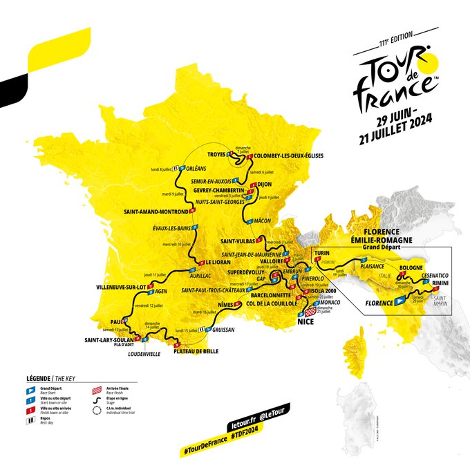
Profiles & Route Tour de France 2024 | Italian start, Galibier on stage 4, gravel, two time-trials, brutal Pyrenees and finale in Nice
CyclingSunday, 23 June 2024 at 11:58
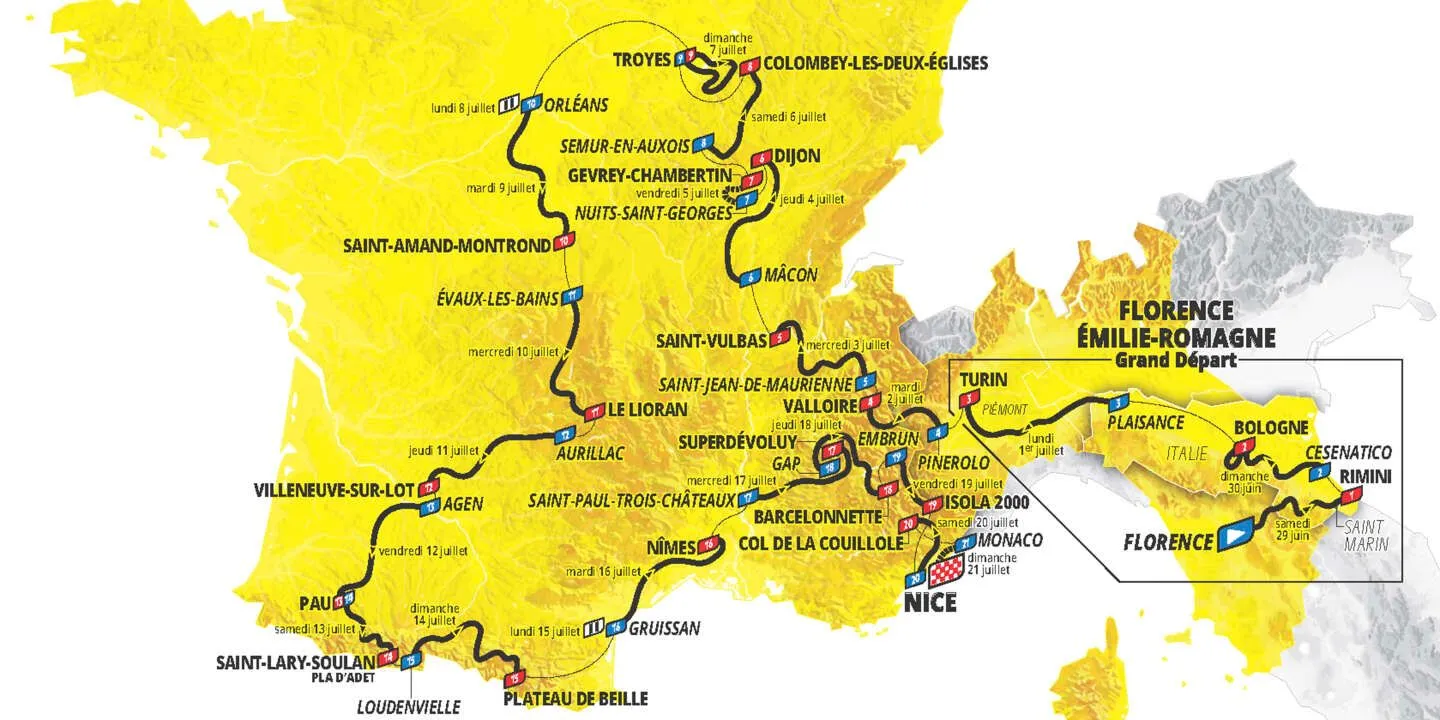
The 2024 Tour de France will be a special edition, with it's Grand Depart in Florence and Emilia-Romagna over the border in Italy, and for the first time in many years, a finale away from Paris as the riders will head into Nice for the race finale. It will take place from the 29th June to the 21st of July. We take a look at it's profiles.
The Grand Depart will take place in Florence and the two opening stages will be suited to the classics riders and climbers with finales in Rimini and Bologne. The third stage will suit the sprinters and end in Turin. The race will end in Nice as Paris will host the Olympic Games that summer, and the final stage will be a time-trial between Monaco and Nice.
After another tough day on stage 4 with the riders heading onto French tarmac, stage 5 will finally allow the riders to get a little bit more respite, with a transition stage between Saint-Jean-de-Maurienne and Saint-Vulbas.
Read also
Stage 7 brings the first of two individual time-trials, before stage 8 and 9 pose further threats to general classification riders with stage 9 especially unpredictable as the white gravel paths of the Côte des Bar, a hilly champagne area, feature.
Then comes a traditional rest day and an expected sprint stage on stage 10 could see many of the riders enjoy a bonus rest as week 2 begins. The main focus of the middle week though, is the introduction of the Pyrenees. The first ride through the infamous area takes on the Pla d'Adet. In the second Pyrenees stage, the finish line is in the Plateau de Beille ski resort, also a well-known Tour mountain.
Stage 20 will be the final day in the mountains for the Grand Boucle, short in distance however it'll be in the Alpes Maritimes that it'll take place, a rough day with four categorized climbs including the Col de Turini, Col de la Colmiane and the Col de la Couillole - all frequent appearances as the queen stages at Paris-Nice.
The race will end in Nice as Paris will host the Olympic Games that summer and the final stage will be a time-trial between Monaco and Nice. The 35-kilometre route will include the ascents to La Turbie (8.1Km; 6.5%) and a short hilltop to the Col d'Èze (1.6Km; 8.1%) before descending down to the coastal city which will receive the Tour de France peloton's podium.
Read also
Stage 1: Florence - Rimini
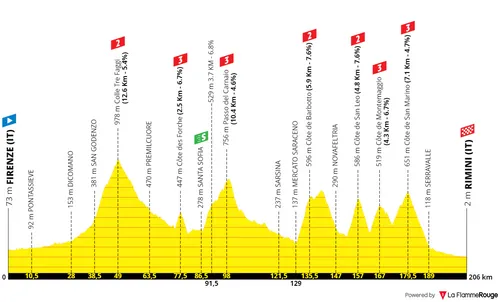
Stage 1: Florence - Rimini, 206 kilometers
The Tour de France starts in Florence this year. In the heart of Italy, the race organizers have cooked up an opening stage with 3700 meters of climbing. This includes six categorized climbs, a very hilly finale before the flat run-in to Rimini where the first yellow jersey will be attributed.
12.6 kilometers at 5.4% is the first climb of the race, a second category ascent. Two third category climbs follow with 2.5Km at 6.7% and 10.4Km at 4.6%. These ascents will be a warm-up however for a day of racing that can cause some damage by the end. Remember that the distance is also of 206 kilometers on the day, which makes it more plausible for differences to be made.
The Côte de Barbotto opens up action for the stage finale. It's 5.9 kilometers at 7.5%, perhaps the toughest ascent of the day which summits with 70 kilometers to go. It's a constant up and down throughout the following hour of race and here things can open up quite a bit.
Côte de San Leo is the next one, 4.8 kilometers at 7.6% with a section well above 10%... It ends with 49 kilometers to go and has a descent right after which leads directly to the third one of the day. 4.3 kilometers at 6.7% which ends with 39 kilometers to go.
The final climb then will be the Côte de San Marino, a technical ascent with many switchbacks, averaging 4.7% for over 7 kilometers. It is the final climb of the day and although it's not overly hard it definitely provides another opportunity for attacks. The riders the descend back down from the micronation and towards the Adriatic city of Rimini.
The final 15 kilometers will be flat and provide an opportunity to organize. A lot can happen in these kilometers, it will depend a lot on how the riders tackle the climbs. A large bunch sprint will not happen but a small one may; and in the final kilometers there is definitely a technical aspect which also favours attackers.
Just inside the final 1.5 kilometers there are three 90-degree corners and the final straight, right by the sea, is pan-flat and 800 meters long.
Read also
Stage 2: Cesenatico - Bologna

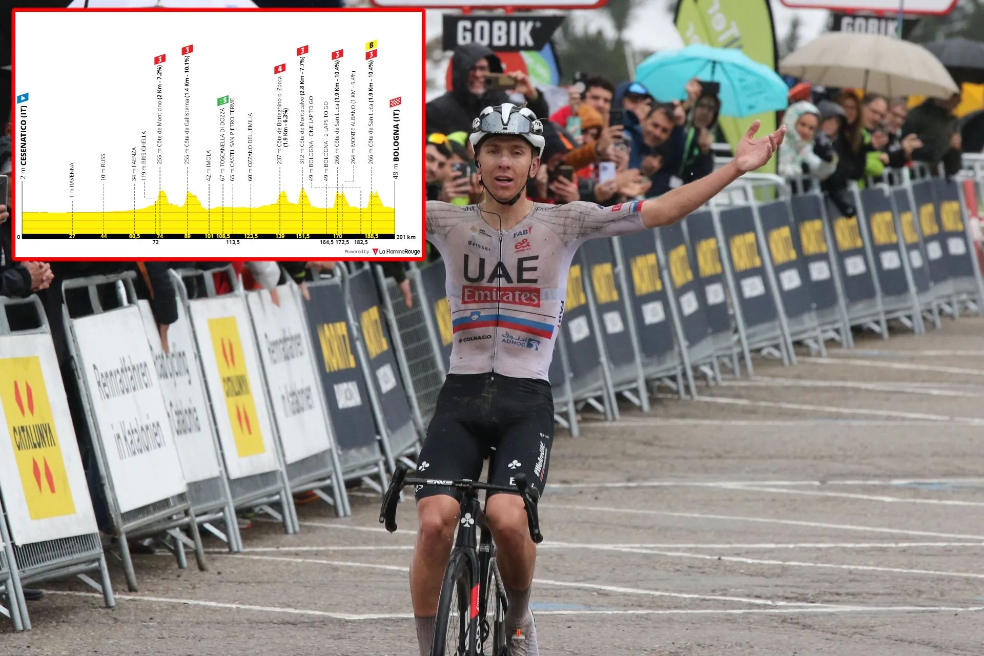
Stage 2: Cesenatico - Bologna, 200 kilometers
Stage 2 may be the first day of the race where the overall classification can explode. The first day certainly has potential for it, but on the second day of racing the riders climb up the Madona di San Luca on two occasions. The climb - which is raced every year at the Giro dell'Emilia is short but very steep and explosive, and can create differences before descending back into town for the finale.
201 kilometers on the menu, it's another long day on the bike and it features an easy start, and rough finale. We focus on the final 70 kilometers. The peloton tackles two hilltops of 1.9Km at 6.3% and 2.8Km at 7.7%. The latter comes with 50 kilometers to go, and then comes the double ascent of the Madona di San Luca - the first very steep climb of the race, which can lead to meaningful GC differences.
If the climb is attacked on the first lap and weaknesses are exposed, it can lead to a very bad start for some GC riders. But likely the main favourites will save their bullets for the final time up the climb. The climb is 1.9 kilometers long at 10.4% and has the maximum gradient of 16%. It's a grueling small ring climb, long enough for it to fit the climbers better than the classics specialists. The ascents finish with 31 and 12.5 kilometers to go.
The stage does not finish atop the ascent however, unlike the Italian classic which it headlines. A short descent comes right before another small hilltop of 5% throughout a whole kilometer. A technical descent then leads the riders down to Bologna. The final 6 kilometers then are completely flat and non-technical. Gaps can be opened or closed, but this will definitely be a day only to be contested by those that can climb well whilst you can definitely expect a fight for the yellow jersey.
Read also
Stage 3: Piacenza - Torino
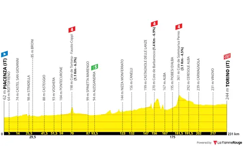
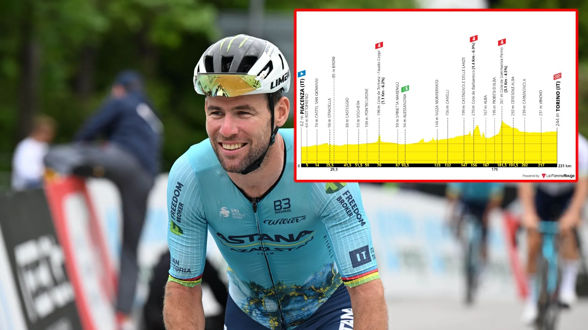
Stage 3: Piacenza - Torino, 229 kilometers
The sprinters will finally have their first real opportunity on stage 3 of the Tour. It's a transition day, a whole 229 kilometers on the menu but overall one of the flattest days of the race. The stage finale will be in Torino, a city which has already hosted the finale of the first stage of the Giro d'Italia this year.
It's a flat day, the first day for the pure sprinters and the final full day in Italy. Almost nothing noteworthy, it's a completely flat day until the final third; with two hilltops - the last of which ends with 50 kilometers to go. Enough time to take some rest and calm back down before the teams begin to prepare for the sprint.
It will be a fast and tense finale. A true race until the 1.2 kilometers to go where there will be a very sharp corner. Then just inside the final kilometer there will be another one. The riders will make it to the final sprint in the blink of an eye so positioning will be crucial and it will be a furious finale with a fresh peloton.
Read also
Stage 4: Pinerolo - Valloire
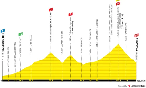
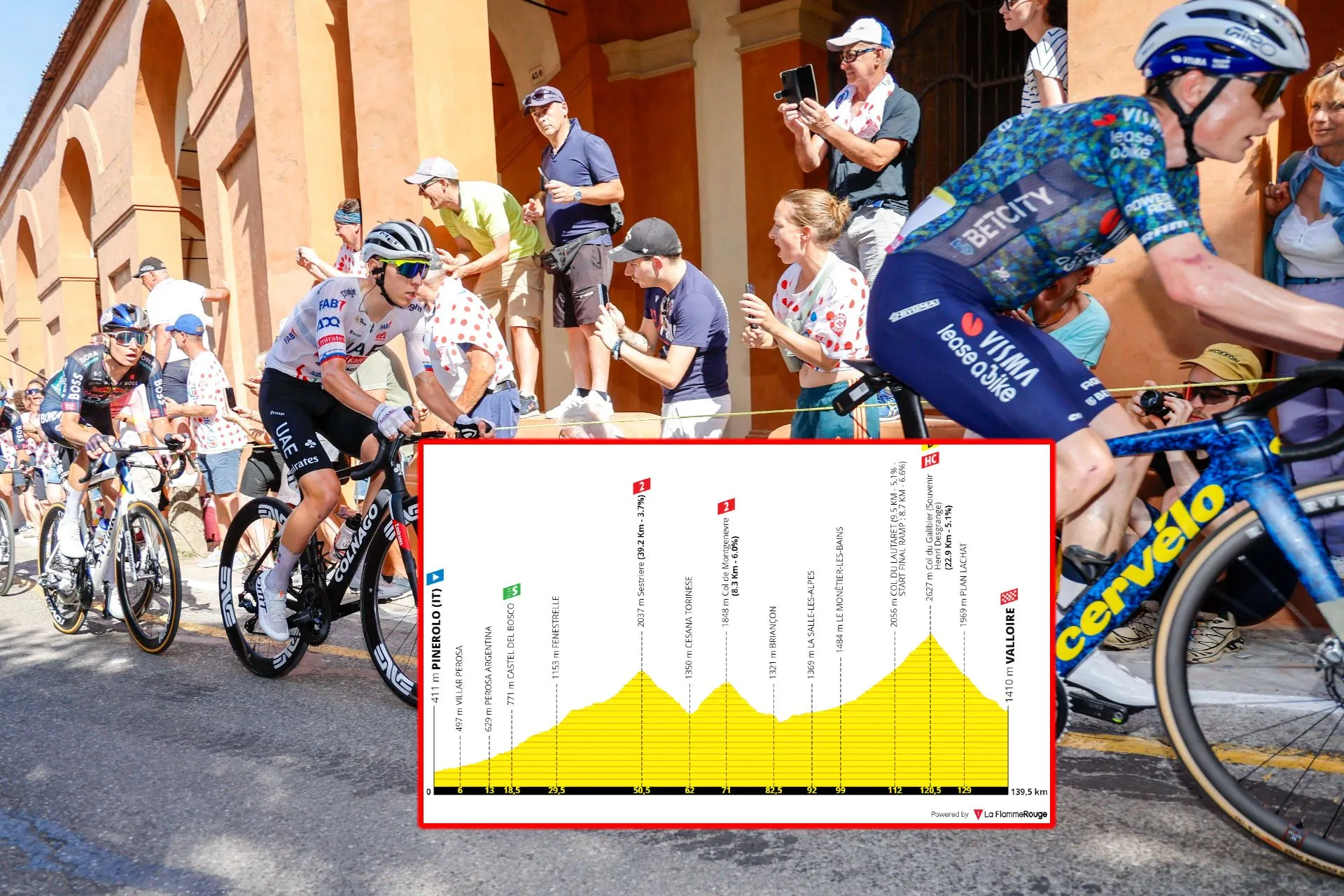
Stage 4: Pinerolo - Valloire, 138 kilometers
And on day 4 of the race, the peloton crosses the border into France, through the Alps. But this will not be an easy or transition day, instead the first day in the high mountains. After climbing 1600 meters of altitude into Sestrière, the GC riders will have their first taste of true climbing in this race and they will do so all the way into the Col du Galibier.
The riders start in Pinerolo at 400 meters of altitude and through a valley will go up all the way into 2037 meters at the summit of the second category climb. It's not one that will make differences but it's not everyday that the riders tackle such a long climb. Some fatigue will set it for sure.
After the descent follows the climb to Col de Montgenvre which is 8.3 kilometers long at 6%. This ascent ends with 68 kilometers to go. A small descent follows and then the riders build up towards the famous Col du Galibier.
Via the Col du Lautaret, this is the easier side of the hugely popular climb, but with 23 kilometers at 5% (the steepest towards the summit) and altitude of over 2600 meters at the summit it can cause damage. Die-hard fans will remembers this as the climb where Andy Schleck won back at the 2011 Tour after an incredible raid in the mountains.
But in it's majority it's not a hard climb. Up until the Col du Lautaret it's a long valley road that doesn't go above 5%, only then does it steepen a bit more. Not overly hard, but it definitely gets harder towards the summit and the gradients go up to 11% right up to the summit, also where there are plenty switchbacks which provide opportunity for differences to be made.
The climb ends with 19 kilometers to go. Almost the whole way to the finish line is downhill. In Valloire there are a few corners and flat roads, but the riders lose 1200 meters in altitude. The start of the descent very exposed and technical, whilst towards the end it gets quite faster.
Read also
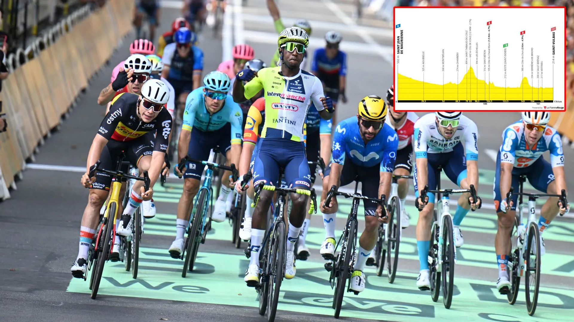
Stage 5: Saint-Jean-de-Maurienne - Saint-Vulbas
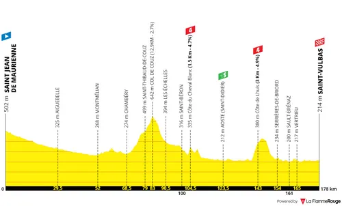
Stage 5: Saint-Jean-de-Maurienne - Saint Vulbas, 177 kilometers
On the fifth day the race starts in the Alps, on the hub city of Saint-Jean-de-Maurienne, but it will be a day for the sprinters as the riders head out of the mountains. We will certainly have a bunch sprint in the industrial area of Saint Vulbas.
13 kilometers at almost 3% ending with 95 kilometers to go and 3 kilometers at 5% with 35 kilometers to go are the two climbs to take into consideration on the day. It's not impossible for some team to try and push the pace in the latter, it's close enough to the finish to drop a few sprinters, but this is unlikely.
The likely scenario is a regular bunch sprint. The riders go all the way into Saint Vulbas but never go into the town center. Instead they ride away from it a few kilometers. Two slight turns with 2.8 and 2.3 kilometers to go will thin down the peloton a bit. A normal bunch sprint finish, although you could argue there is a slight right-hand bend with only 200 meters to go - UCI, where are you?
Read also
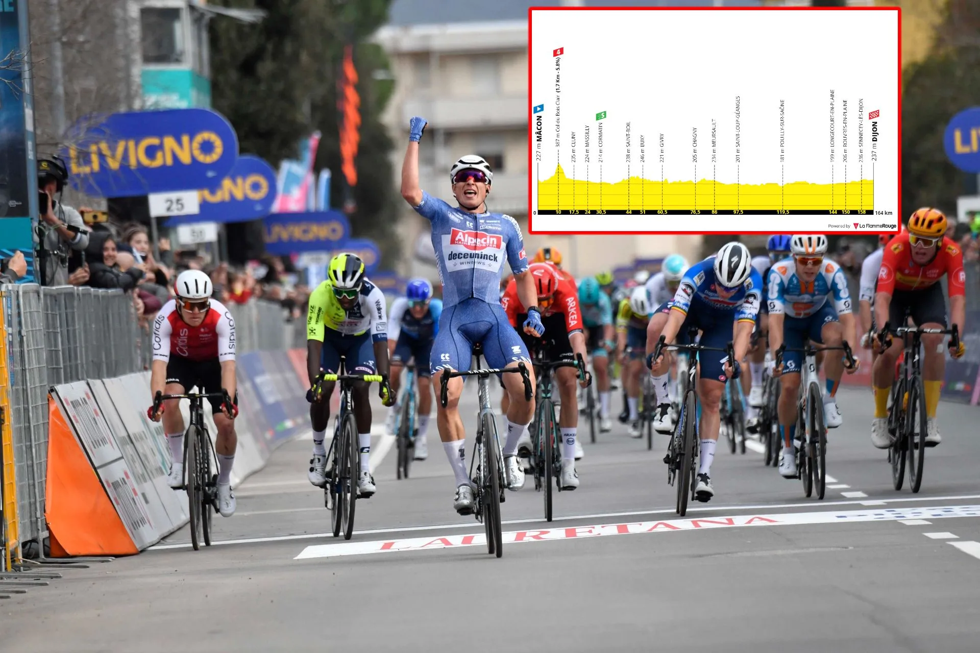
Stage 6: Mâcon - Dijon

Stage 6: Mâcon - Dijon, 163 kilometers
Stage 6 of the Tour should be a calm day on the bike, with only 163 kilometers to race, mostly completely flat with a finale into Dijon. A small fourth category ascent early in the day, but after that it is just an old-school Tour day where there is nothing to keep an eye on besides the final sprint.
This will be an urban sprint, but not a technical one. The peloton will arrive in the city very fresh after a short and easy day on the bike, which will mean speeds will be very high. There isn't any meaningful features except for a big roundabout that comes with 700 meters to go. A race to this point, and then finally the sprint only seconds after.
Read also
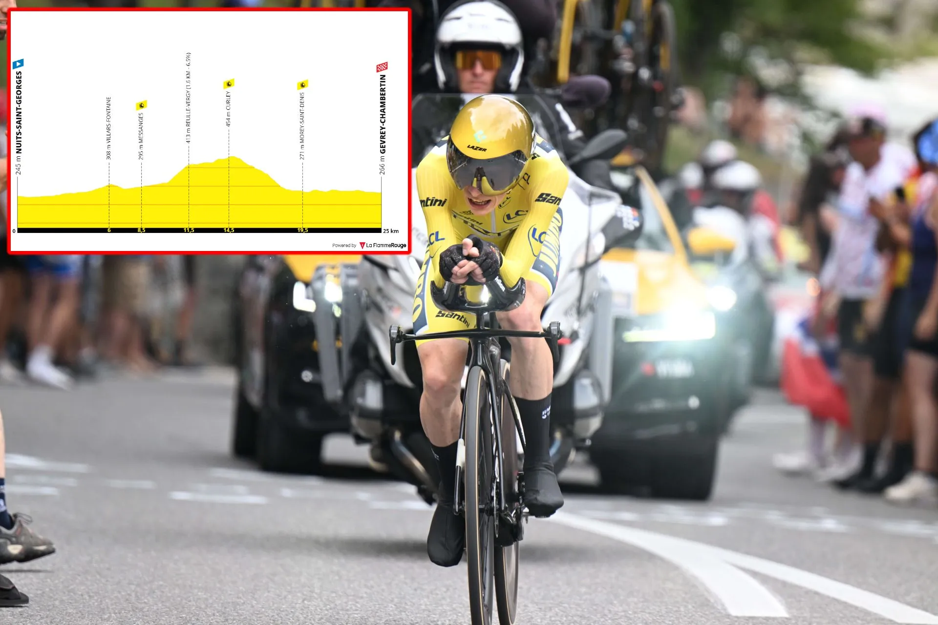
Stage 7 (ITT): Gevrey-Chambertin - Nuits-Saint-Georges
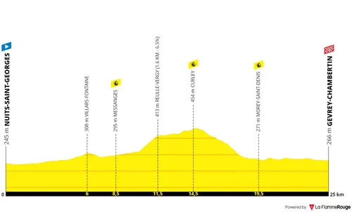
Stage 7 (ITT): Nuits-Saint-Georges - Gevrey-Chambertin, 25 kilometers
The first time-trial of the race. The Tour has steered away from flat time-trials but this is the one, if you could call it that. There is a small ascent and descent halfway through the 25-kilometer course ending in Gevrey-Chambertin, but most of the route will allow the specialists to make some differences.
The course is not technical in any way - except for the final meters which have two corners. There is a small hilltop of 1.6 kilometers at 6.5% between intermediate points 1 and 2 followed by a plateau. Big efforts will be set here, as the descent after allows for some rest. Tactics will matter on the day.
The descent will require some caution because of the high speeds whilst the final kilometers will be completely flat.
Read also
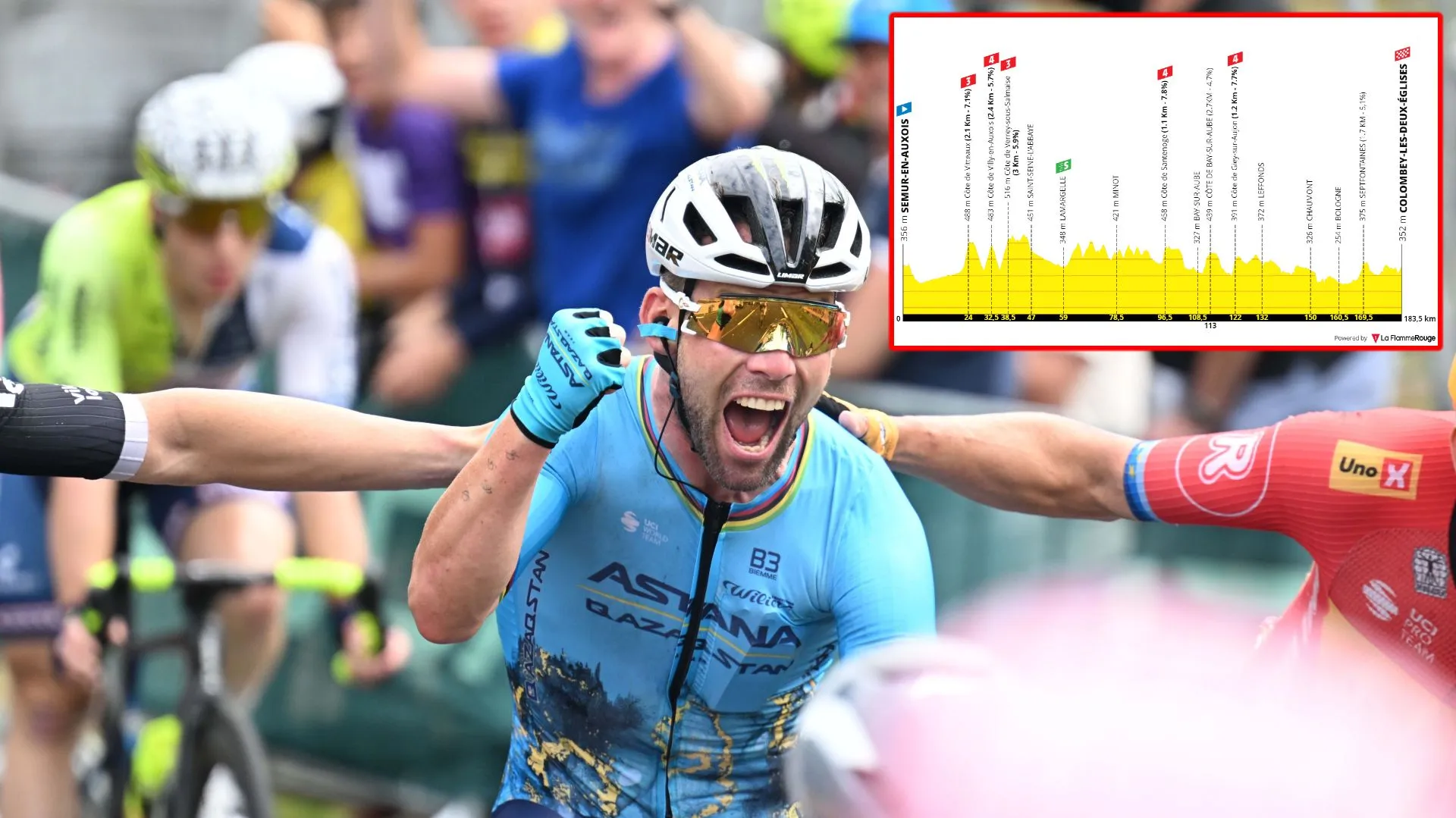
Stage 8: Semur-en-Auxois - Colombey-Les-Deux-Églyses
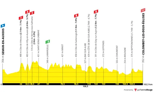
Stage 8: Semur-en-Auxois - Colombey-les-Deux-Eglises, 176 kilometers
Stage 8 is an interesting one, most likely for the sprinters, but throughout the 176 kilometers there will be plenty small ascents. A rough day to control and a difficult one for the pure sprinters; it also provides a good opportunity for breakaways and late attacks.
2300 meters of climbing, it really is an unusual day. Some sprinters will definitely be annoyed as right from the gun there'll be climbing. Three categorized climbs within the first hour of racing, two more halfway through the stage, but a few more equally difficult little climbs throughout the day.
With 14 kilometers to go ends a 1.7-kilometer long climb at 5%. With 6 kilometers to go there is a smaller ascent with similar gradient. Attacks may happen, but I think overall these will serve to suffocate a few sprinters. The pure sprinters should still be in contention, but the final kilometer is also not favourable to them.
It's absolutely not technical, with no corners or street furniture anywhere in the final kilometers. The riders will soar through fields into Colombey-les-Deux-Eglises and the final meters will have a gradient of 4% for the sprint.
Read also
Stage 9: Colombey-les-Deux-Églyses - Troyes
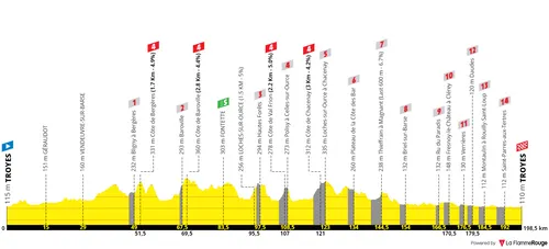
Stage 9: Troyes - Troyes, 199 kilometers
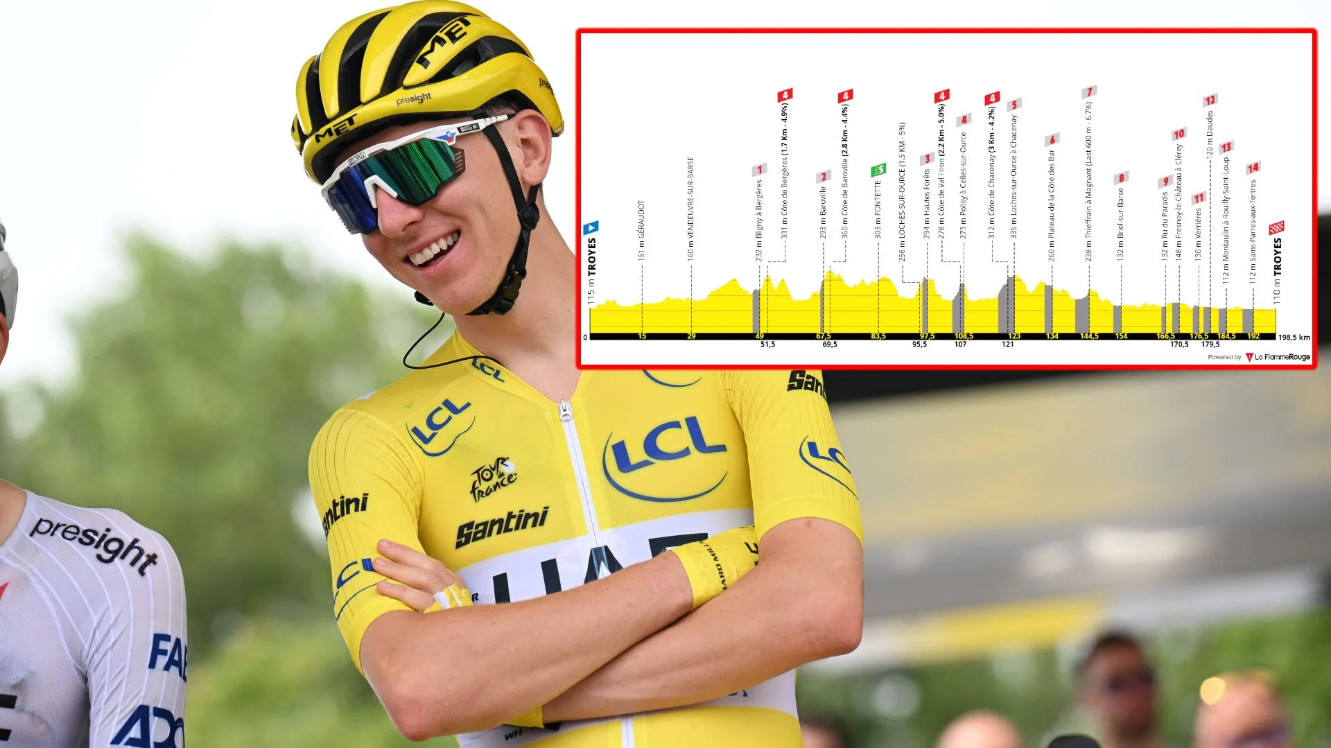
Perhaps the most anticipated stage of the whole race! In the second Sunday of the race the peloton will start and finish the stage in Troyes. A loop which will include 14 sectors of gravel roads, totaling to 32 kilometers in total (most of which in the final two thirds of the stage). There are hills also to contest in the day, but into the city there will be plenty fast and treacherous sections.
The sectors have the following stars (based on difficulty by the race itself), distance and also distance to the finish at the end of the sector. The following sector numbers are as presented by the race and not the profile above.
Sector 14 - 1 star. 2Km. 149Km to go.
Sector 13 - 3 stars. 1.2Km. 131Km to go.
Sector 12 - 2 stars. 1.5Km. 101Km to go.
Sector 11 - 3 stars . 3.4Km. 90Km to go.
Sector 10 - 3 stars. 4.2Km. 75.5Km to go.
Sector 9 - 1 star. 2.2Km. 64.5Km to go.
Sector 8 - 3 stars. 3.9Km. 54Km to go.
After this point there will be no more climbing, but instead flat gravel roads. Less difficulty on the road but faster and more treacherous sector, with positioning also being more important. Sector 7 comes right after the descent, but the final six sectors then will be tightly packed together.
Sector 7 - 1 star. 2.2Km. 44.5Km to go.
Sector 6 - 1 star. 1.2Km. 32Km to go.
Sector 5 - 1 star. 1.8Km. 28Km to go.
Sector 4 - 1 star. 1.5Km. 22Km to go.
Sector 3 - 1 star. 1.9Km. 19Km to go.
Sector 2 - 2 star. 2.2Km. 14Km to go.
Sector 1 - 2 star. 3Km. 6.5Km to go.
Read also
Stage 10: Orléans - Saint-Amand-Montrond, 187 kilometers
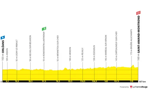
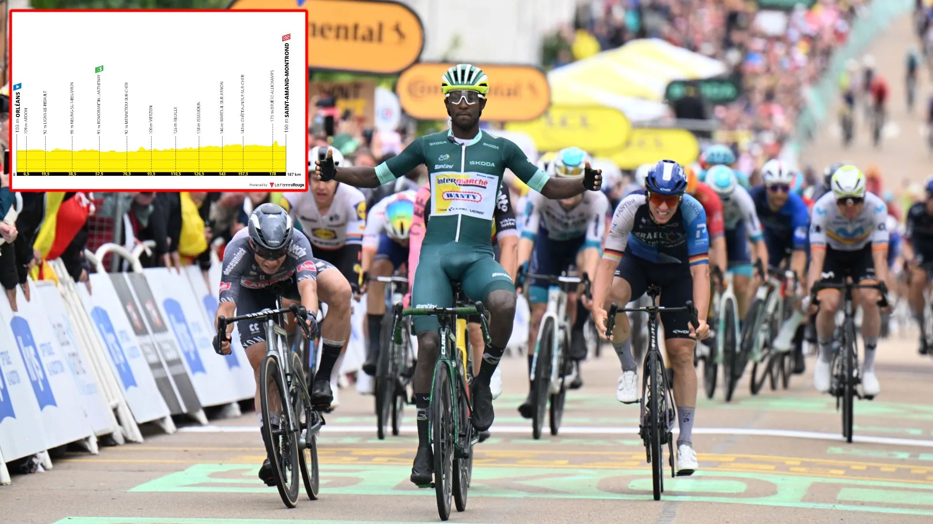
Stage 10: Orléans - Saint-Amand-Montrond, 187 kilometers
Stage 10 is the start of the second week of the Tour. An easy start for it, the day takes place from Orléans to Saint-Amand-Montrond is completely flat and a golden opportunity for the sprinters.
What can be said about this day? Very little. An intermediate sprint early on after only 57 kilometers. A tiny ascent that finishes with 7 kilometers to go before the expected bunch sprint.
This one will be quite regular but with a special feature added. It will be a very fast sprint but in order not to have a completely straight line, organizers created a small obstacle in the final kilometer. Three slight corners, from 850 to 500 meters to go. Then full speed to the finish line.
Read also
Stage 11: Evaux-les-Bains - Le Lioran, 211 kilometers
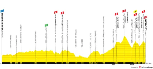
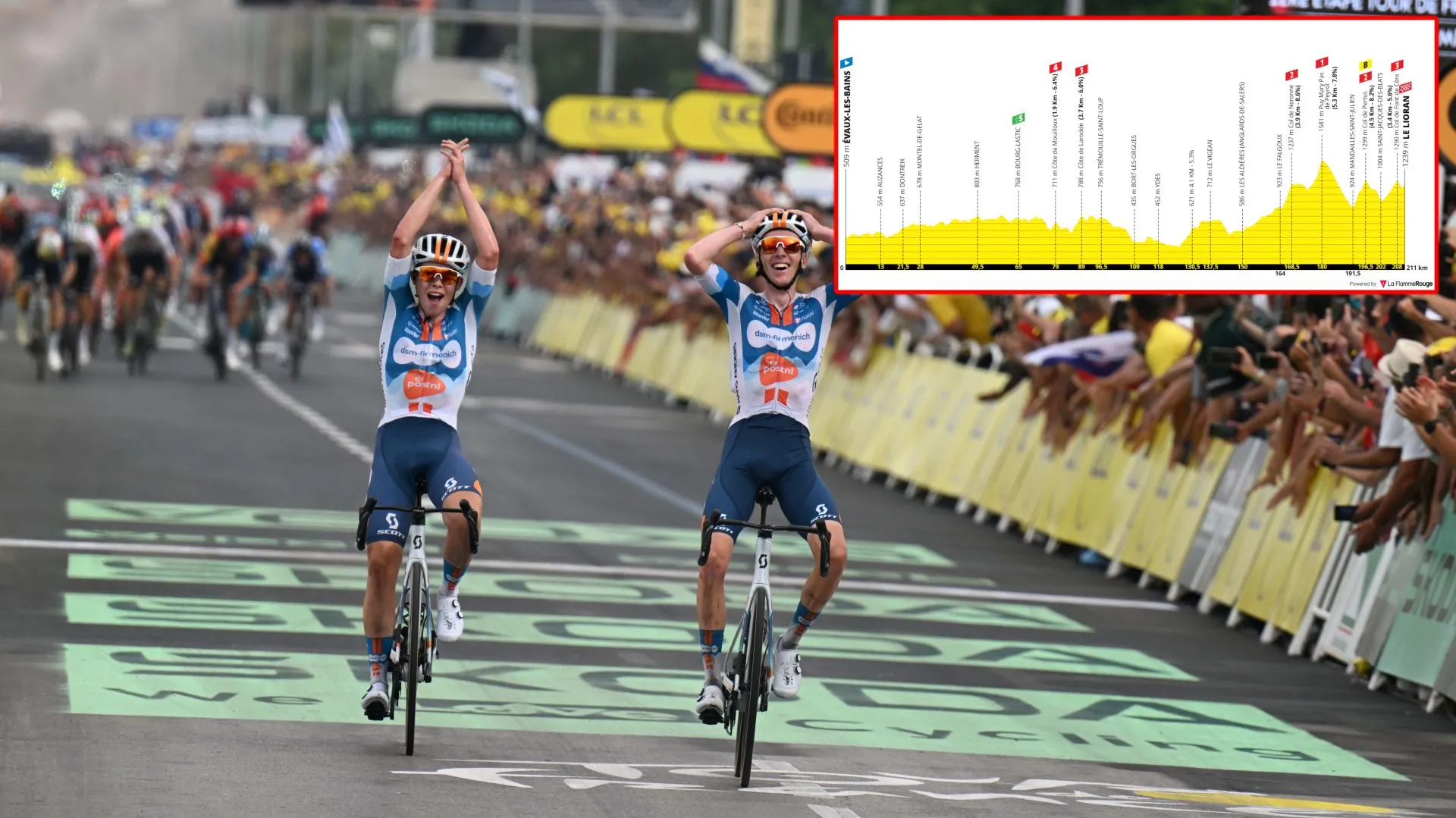
Stage 11: Évaux-les-Bains - Le Lioran, 211 kilometers
Into the Massif Central, the race is now heading south towards the Pyrenees. The beginning of the 211-kilometer stage is flat but the finale is rather hilly with four categorized climbs. The GC riders could have an interesting battle, but most likely we will have a breakaway contest for the triumph.
It is a transition day, well suited to a breakaway however with a flat start that certainly won't make it easy. 211 kilometers on the bike will make it a long one, with a difficult finale where the climbers and classics riders will come to the front. If the GC men find an opening, the fight could easily explode in such terrain.
The Massif Central presents treacherous roads and a different challenge to that of the high mountains, which some may want to take advantage of. The final 50 kilometers of the stage has four difficult ascents. The first of which is the Col de Neronne which is 3.9 kilometers long at 8.6%, it ends with 42.5 kilometers to go, and there is no descent before tackling the next one.
This is the Puy Mary Pas de Peyrol which is 5.3 kilometers long at 7.8%, summiting with 31 kilometers to go. But this is a very dangerous ascent as the gradients go all the way up to 16% close to the summit and the riders immediately go into a technical and steep descent directly into the base of the next climb. It's a prime location for an explosive attack.
After the descent there is the Col de Pertus which is 4.5 kilometer long at 8.2%, and in it's summit is a bonified sprint with only 14.5 kilometers to go. The peloton can completely explode on this ascent if it hasn't already, as 8 seconds at the top are not to be ignored.
After a small ascent comes the last climb of the day, the easiest of the four but not an easy one by any means - adding the fact that fatigue will be high at this point. The Col de Font de Cère is 3.4 kilometers long at 5.6% and ends with only 3 kilometers to go. It's almost a summit finish. Only a tiny descent follows and then a slight uphill sprint to the line in Le Lioran.
Read also
Stage 12: Aurillac - Villeneuve-sur-Lot
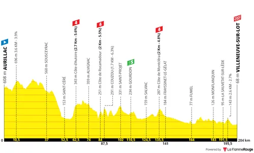
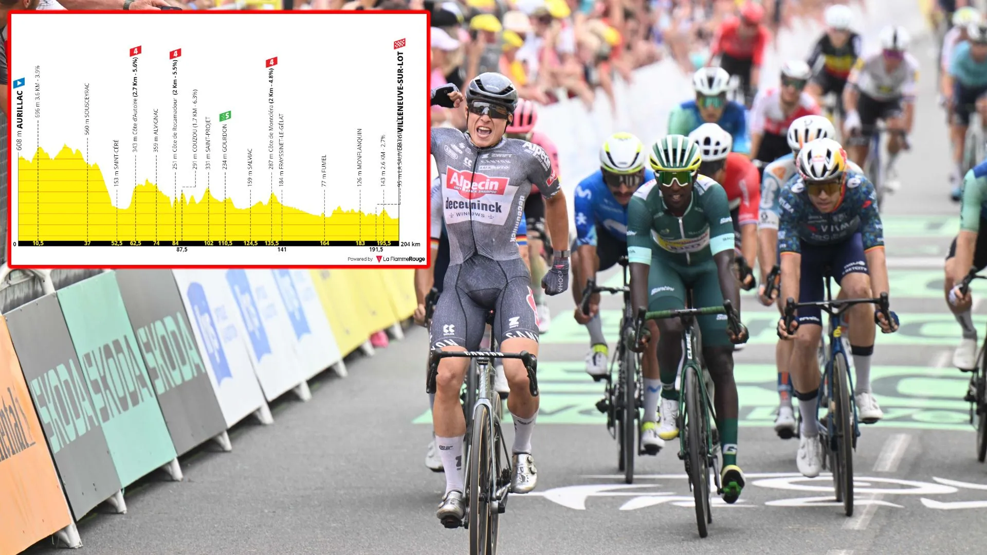
Stage 12. Aurillac - Villeneuve-sur-Lot, 204 kilometers
Stage 12 is a transition day through western France. It is 204 kilometers long from Aurillac to Villeneuve-sur-Lot, a day starting at relative high altitude and finishing close to sea level, with plenty small ascents en route to a finale where a bunch sprint is still the most likely scenario.
It's a day where early on attacks are expected, as it is a well suited day for the breakaway. This time around the Tour has not been gentle on the long stages and these definitely weight on the legs of the sprinters. With 2200 meters of climbing, it also breaks the traditional idea of a regular sprint stage. But it's the downhill trend on the day combined with the many many small ascents that really makes it viable for a strong group to stay away.
The peloton will have to keep a tight leash on any escapee group right from the start of the day, but if it does so efficiently than a bunch sprint remains the most likely scenario. There is a small hilltop that ends with just 8.5 kilometers to go, a final opportunity to put the hurt on the pure sprinters; before an urban finale in Villeneuve-sur-Lot.
It will be a tense sprint with a roundabout, a river crossing and a few treacherous fast corners from 2.5 to 1.2 kilometers to go. But the final straight is 1.2 kilometer long, which means the sprinters won't risk their life to position ahead of this section. There will be a fight, but there is time to recover places in the final kilometer still. The sprint will be flat, albeit perhaps with 1/2% gradient to the line, and in a complete straight line.
Read also
Stage 13: Agen - Pau
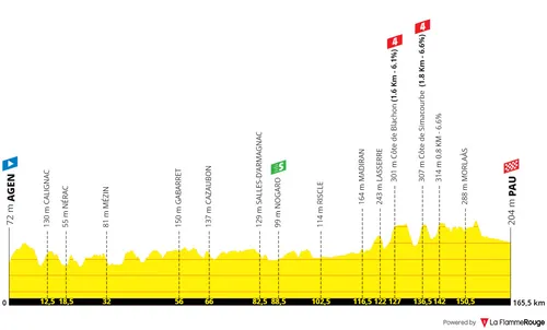
Stage 13: Agen - Pau, 171 kilometers
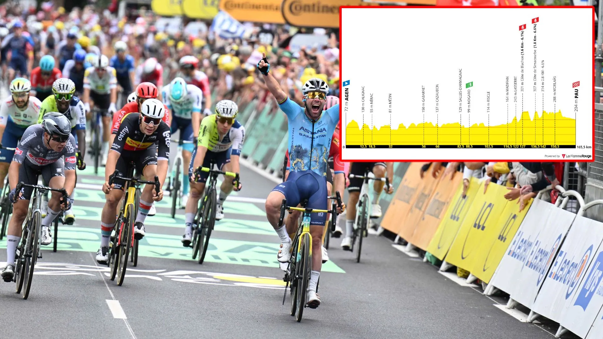
Another day for the sprinters, even if it includes perhaps more climbing than some would hope for. It's a treacherous day as the riders head into the base of the Pyrenees, the hilly start will provide an opportunity for the breakaway whilst the sprinters will look to take the glory on the day.
In sum, another headache for the pure sprinters who just want a flat day and their best chances in a bunch sprint, but have to tackle a string of annoying hilltops. A fast start is expected, with none less than four small ascents where strong rouleurs are expected to make a move. This is a day where a breakaway can succeed with no doubt and so a furious start is expected. The peloton will have to ride a good pace all throughout the day in order to never give it much freedom; but simultaneously they would likely want to not close it too much because it will motivate attacks in the latter climbing section.
With 43.5, 38.5 (1.6Km; 6.1%), 30 (1.8Km; 6.6%) and 24.5 (0.8Km; 6.6%) kilometers to go there is the summit of four small ascents, all in quick sequence. This can serve for a few teams to really push the pace hard - if they do, a few sprinters can certainly be dropped - but also for attacks to come off the peloton with an hour of racing left. With high mountain stages ahead, this will be the last opportunity in a while for a few riders to give it a shot, so we cannot discard that possibility.
After which it calms down, and there is time to reorganize. The riders descend slightly and head into Pau, a very familiar host city of the Tour. Fun fact, it is the third city with the most starts/finishes of Tour history with 74, only behind Paris and Bordeaux. Number 75 (and 76 on tomorrow's start) await the peloton. This time around a sprint, which will be technical.
The final kilometers take place within the city but it will really be important to be at the front into the final kilometer. With 1.1 kilometers to go there is a 90-degree left corner, with 800 meters to go a roundabout and slight right-hander, and with 500 meters to go a full-speed slight turn to the left where there will be no breaking but no opportunity to overtake. At this point we are already almost in the final sprint and those caught out of position will struggle to recover. This is one for the experienced and strong leadouts.
Read also
Stage 14: Pau - Pla d'Adet
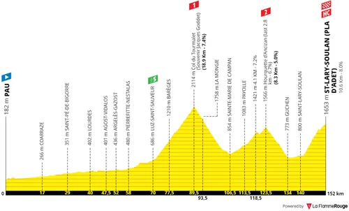
Stage 14: Pau - Saint-Lary-Soudal (Pla d'Adet), 152 kilometers
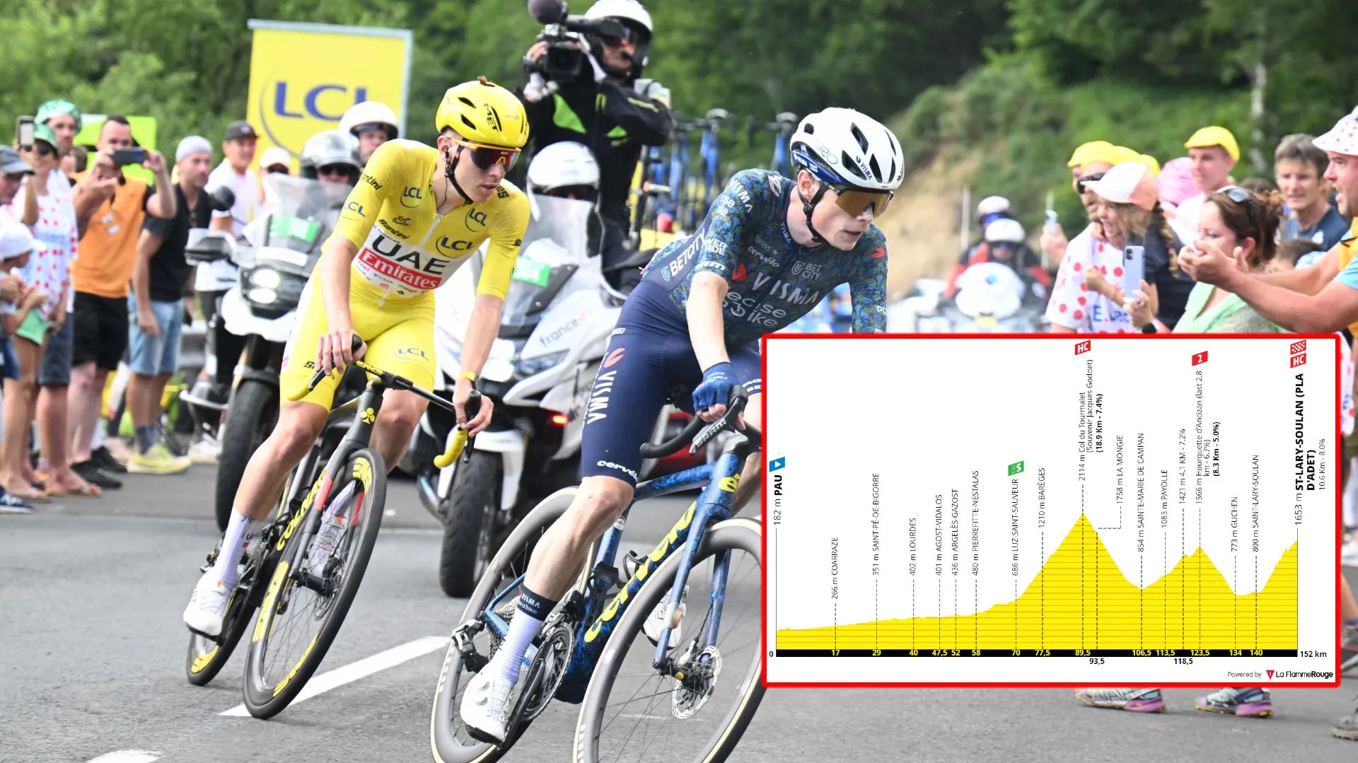
The race is back into the mountains and there is no warming up. The Tour keeps it's modern traditional formula, with a short stage featuring a flat start. So it will be very hard for a breakaway to stand any chances. The GC riders are likely to fight for the win in a day including the Col du Tourmalet, Hourquette d'Ancizan and finally a summit finish on the Pla d'Adet which is over 10 kilometers long at 8%.
The start of the day is... Completely flat, nothing even noteworthy. Most riders will likely just wait until the mountains to really kick off the action, but this is a day where a breakaway is likely doomed because the strong climbers don't have the opportunity to make a difference early in the day. With 70 kilometers of racing, into the second half of the day, the climbing starts and with a big one!
The Col du Tourmalet is the most used climb in Tour de France history and it returns to the menu of the first Pyreneen stage. It is 18.9 kilometers long at a stable 7.4%. A constant climb, an effort of over 45 minutes in steep gradients which will put many into difficulty. For the pure climbers this is close to heaven, and the top is at over 2100 meters of altitude so that statement is not just figurative...
The riders hit the summit with 62.5 kilometers to go and descend off the other side, very quickly they reach the second ascent of the day. The "easiest", it's the Hourquette d'Ancizan which summits with only 28.5 kilometers to go. It's 8.2 kilometers long at just over 5% but this does actually include a whole downhill kilometer. Most of the climb is within the 7/8% gradients, but don't expect attacks here, only more pace setting and preparation for the final climb.
It will be on the Pla d'Adet where all the action is expected. 10.6 kilometers ay 8%, it's a difficult climb and also a bit of a shock to the system because the hardest section is the first half of the climb which averages around 10%. A brute, and you can make serious differences here without a shadow of a doubt. The gradients are slightly lower in the second half, the climbers can do some of it in the big ring, but the damage will have been done closer to the base with certainty.
Read also
Stage 15: Loudenvielle - Plateau de Beille
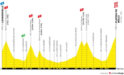
Stage 15: Loudenvielle - Plateau de Beille, 198 kilometers
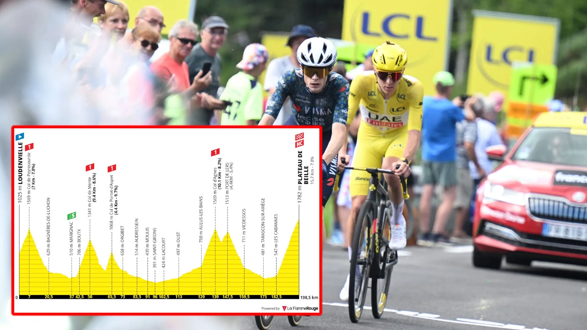
The queen stage? Perhaps in a different edition yes, I wouldn't say it's the case here, but it is just a brutal mountain stage to wrap off the second week. With the rest day ahead the riders will not save themselves on a day with four first-category climbs and an HC summit finish. There will be 5000 meters of climbing and it is the stage with the most climbing meters.
The riders tackle the Col du Peyresourde right from the start of the 198-kilometer day. This is a proper mountain stage, the kind that the Tour now rarely offers. Right from the gun the peloton rides up one of the Tour's most famous climbs which is 7 kilometers long at 7.8%. Expect action here, with the climbers going crazy off the front.
After descending the riders tackle the Col de Mente. I reckon this is the hardest climb of the day but it ends with around 150 kilometers to go still. It's 9.4 kilometers long at 8.6%, steep and very constant with a lot of switchbacks towards the summit.
After the descent comes the Col de Portet d'Aspet, the steepest climb of the day which is 4.4 kilometers long at 9.7%. Although it's very difficult, the descent requires maximum attention as it is very technical and dangerous. It ends with 133 kilometers to go. The following hour provides an opportunity to rest and prepare for the stage finale.
The Port d'Agnes follows, it's 10.1 kilometers long at 8.2%, another brute. This climb ends with 49.5 kilometers to go and the pace can seriously ramp up at this point in the day. A very technical short descent leads the riders to the uncategorized Port de Lers which is 4.4 kilometers long at 5.4%, and this one ends with 41 kilometers to go.
Very quickly the riders reach the base of Plateau de Beille. Funnily, despite being very difficult, the summit finishes atop this ascent in 2011 and 2015 barely created any differences among the GC contenders. An interesting scenario, but at the end of a 200-kilometer and 5000 climbing meters-stage it may not be the same this time around.
The climb is 15.7 kilometers long at 7.8%. It has it's steepest points, above 10%, from 8 to 6 kilometers to go and the main attacks could happen here. But overall it's a hard climb that is relatively constant and with plenty switchbacks. Everything is set for a mammoth GC battle.
Read also
Stage 16: Gruissan - Nîmes
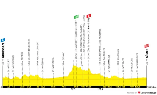
Stage 16: Gruissan - Nîmes, 187 kilometers
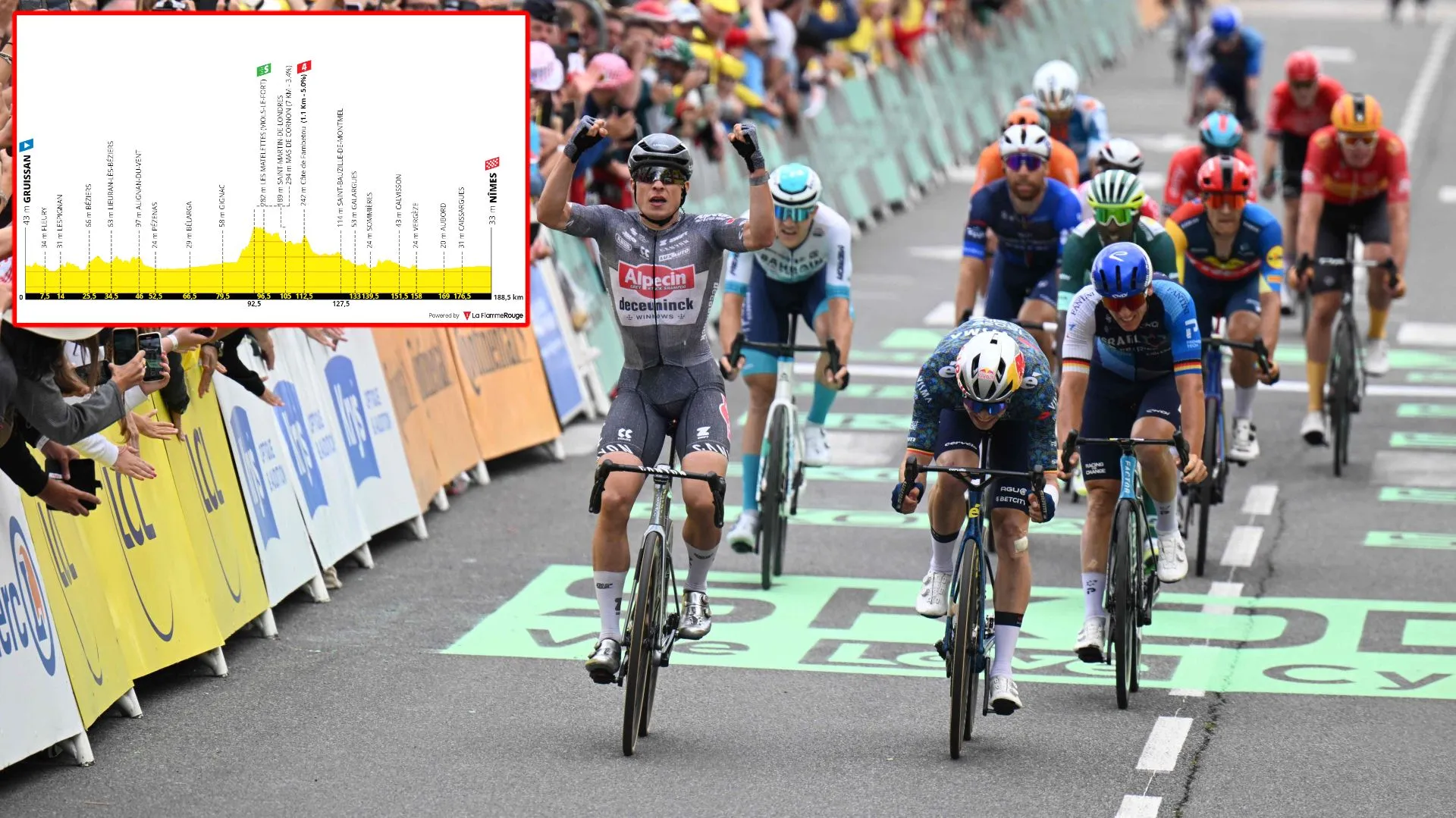
The third week begins with a sprint stage; perhaps the only one of the final week. This is a stage where the peloton moves east from the Pyrenees towards the Alps and finishes in the city of Nîmes.
All-in-all a calm day, unless the wind is present which is very possible. but profile wise it's a stage with a relatively easy start and only one small ascent to take into consideration throughout the day. The sprinters will be happy - but the pressure and risks will be through the roof as this is the final opportunity for a regular bunch sprint in the whole Tour! (No Champs-Elysées this year)
It's all about the final sprint, and it's not a technical one. The riders will not go deep into the city but finish in it's outskirts. The final corner comes with 2.5 kilometers to go and then it is a straight line into the finish. But take into consideration that the peloton will have three small roundabouts to tackle in the final two kilometers and the last of which comes with only... 450 meters to go. So positioning is key into this spot.
Read also
Stage 17: Saint-Paul-Trois-Châteaux - Super-Dévoluy
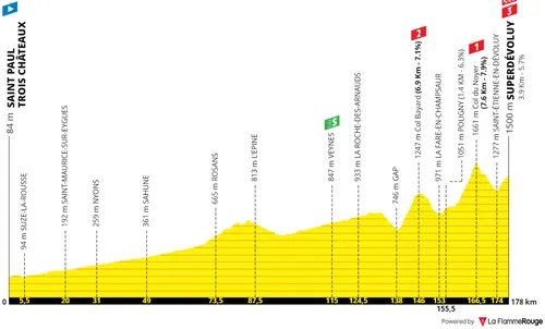
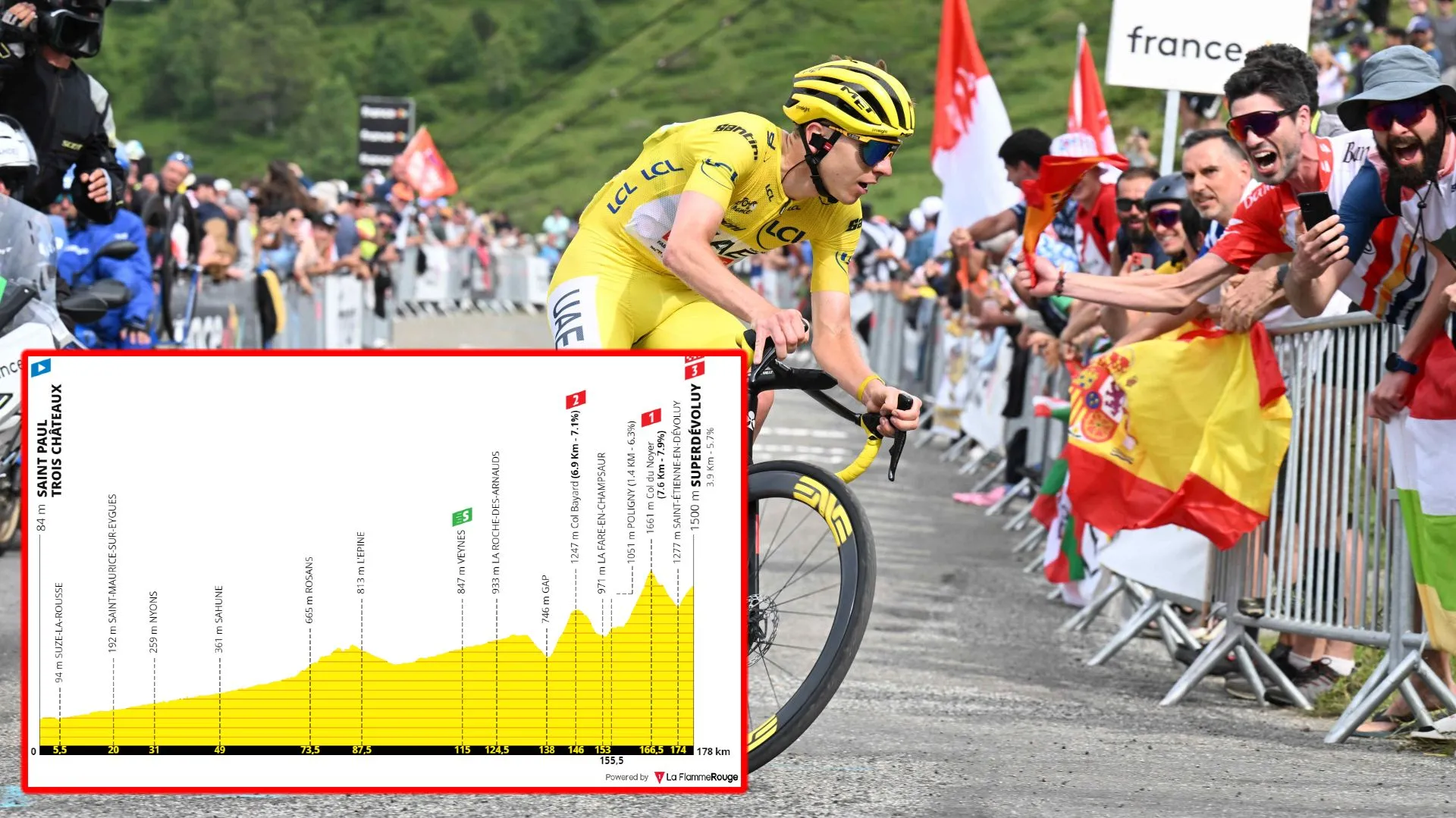
Stage 17: Saint-Paul-Trois-Châteaux - Superdévoluy, 178 kilometers
A mixed day. It is one where the breakaway should succeed but the start is completely flat. The GC riders could be called for action in the hilltop finish to Superdévoluy, which comes after the explosive Col du Noyer (7.8Km at 7.9%).
It's a mixed day, an interesting one actually, breaking the traditional format of the Tour. The next day should be for a breakaway or sprint, and so the GC riders won't necessarily save themselves. The climbs are more explosive which provides a different challenge, but they are still hard enough to make differences. With the completely flat stage start - and mostly flat two first thirds of the stage - there is a serious chance that the main climbers will fight for the win, bonifications and look to put their rivals into difficulties.
The Col du Bauard opens things up, 6.9 kilometers at 7% which ends with 32 kilometers to go. But all eyes will be on the first-category ascent to the Col du Noyer. At the end of a relatively easy day, we can see some serious wattages on this climb. It slowly rises in gradient all the way to the summit and it ends with only 11.5 kilometers to go. It goes above 10% towards the end, this can make bigger differences even than some high mountain stages because it will not be all about pacing.
But the stage does not ends in it's summit in fact. A very fast descent leads the riders into the final hilltop at Superdevoluy. The ascent is 3.9 kilometers long at 5.7%, it will not be enough to create meaningful differences, but it can lead to an interesting fight for the stage win for sure.
Read also
Stage 18: Gap - Barcelonnette, 179 kilometers

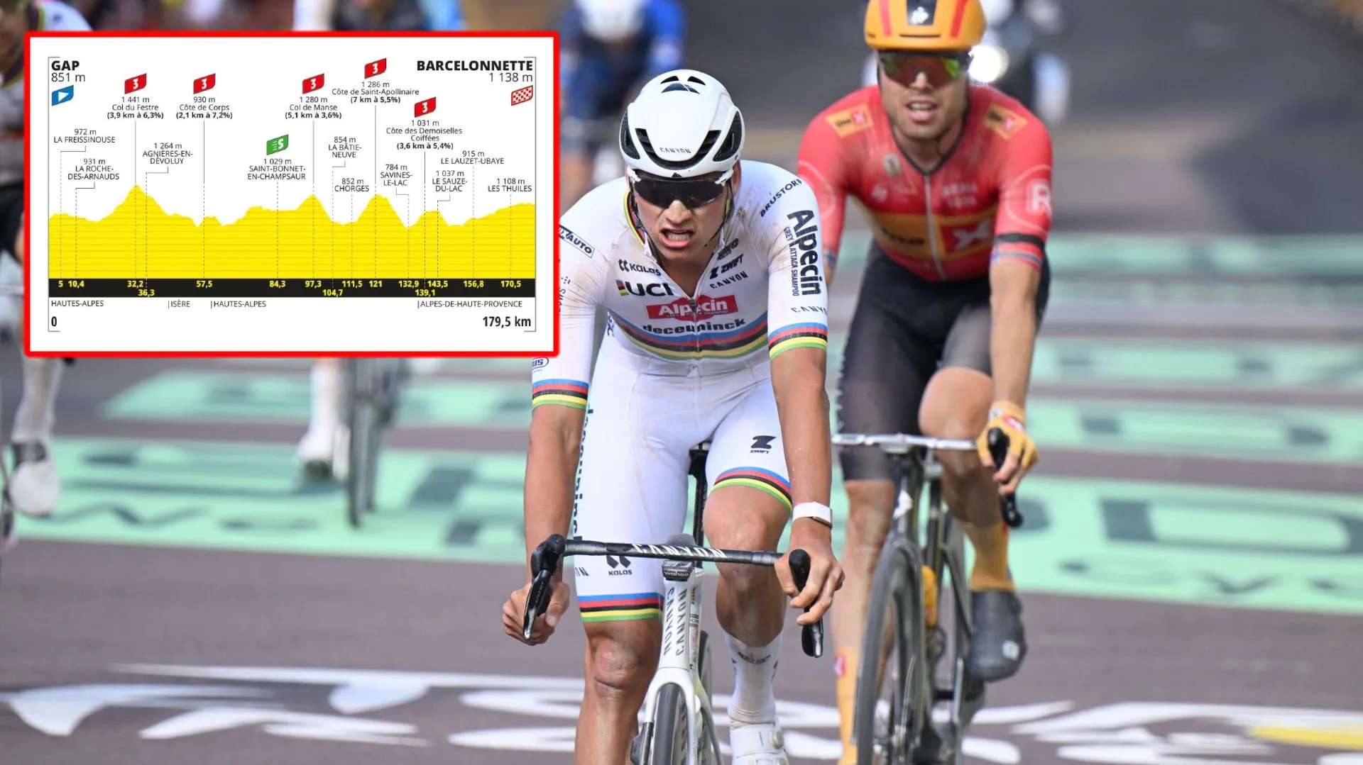
Stage 18: Gap - Barcelonnette, 179 kilometers
An interesting hilly day in the Alps, starting in Gap and finishing in Barcelonnette. The race organizers avoided adding any major climb to the day, but instead some small ascents. This is a day where a breakaway victory is almost certain, but some of the sprinters can climb and certainly a few teams may want to try and control the race for a final shot at a sprint victory.
All in all a very unusual day for a final week of the Tour, but that is a complement. It's a relatively novelty, a day fully in the Alps but showcasing some smaller climbs and purposefully avoiding high mountains so that it's a stage open for dozens of riders to be able to fight for a victory. And how the stage will be decided is a complete unknown.
The riders face a small hilltop right from the start of the stage which may see the breakaway formed right there. If not, the 14-kilometer climb that follows (only 4 kilometers are officially categorized, for some reason) should do the trick. Strong climbers, but also classics riders and rouleurs can move off the front here, as the gradients are never very steep.
Throughout the day then are a few non-steep, moderately hard ascents where attacks can come:
122.5Km to go - 2.2Km; 6.5%
106Km to go - 2.6Km; 6.1%
83Km to go - 5.2Km; 3.7%
59Km to go - 7.1Km; 5.6%
41Km to go - 3.5Km; 5.3%
24.5Km to go - 2.7Km; 4.5%
Note that this is the Tour de France, with brilliant climbers everywhere - both in and out of the GC battle. Destroying a group on climbs like this will not happen, but small groups can move off the front and then collaborate. But just as likely to succeed are attacks inbetween the ascents, with riders who can then survive the climbs. Anything can happen really, and different kinds of riders will play to their own strengths.
It is unlikely, but possible that in the peloton a couple teams try to control things and bring it back to a sprint, as the terrain is not brutal and if the breakaway is not too strong, it can be controlled. The final 28 kilometers are on a slight ride but the final kilometers are flat into Barecelonnette. The sprint, if it happens, is also flat.
Read also
Stage 19: Embrun - Isola 2000
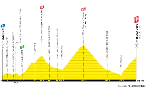
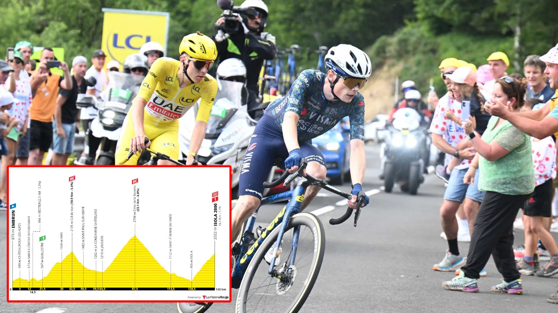
Stage 19: Embrun - Isola 2000, 145 kilometers
Another brutal day. Rather short with only 145 kilometers but with the Col de Vars early in the day, but then the Cime de la Bonnette... The climb summits at a scary 2800 meters of altitude, but the climb in itself is 22 kilometers long at 6.8% - perhaps the most difficult ascent of the whole race. But the riders won't be able to have a smile at it's summit, as the stage then descends back into the valley and climb up Isola 2000 (16.1Km; 7.1%) for the stage finish.
The first 20 kilometers of the day should be fast but the climbers looking to win from a breakaway will likely wait for the Col de Vars to make their move. The climb is 19 kilometers long at 5.6%, but this includes small downhill. The first 8 kilometers of the climb average around 7% and it's hard enough to make differences. It's still a long effort however and the mountain goes all the way up to 2105 meters of altitude. Altitude is a key word on this day.
Because the Tour will tackle its highest climb of the year. The Cime de la Bonnette is the highest-altitude climb ever used in the Tour de France and it is the highest paved road in Europe that doesn't have a dead end (meaning it can be climbed from two different sides. It is also the third highest paved road in Europe only behind the Pico Veleta and the Tiefenbachferner.
This is a good introduction to just how high the riders will go. It's the fifth time the climb is in the race, the last of which was in 2008, but it was part of the Giro d'Italia in 2016 (where the riders raced in the same direction as this day, with Isola 2000 also in the route). But the climb is not just about the altitude, it's details are just brutal as well. It's 23.1 kilometers long at 6.8%, a climb that will take around an hour even for the best climbers in the world.
The ascent ends with 57.5 kilometers to go but have no doubt that at this point in the Tour, and with just how hard of a climb it is, some GC riders may go all-out - specially those who love the altitude and long ascents. The fact that the descent starts at 2798 meters of altitude and is technical will make it a tense challenge as well, on a road that is fully exposed to the weather.
In 40 kilometers the riders lose 2000 meters of elevation until they face the final climb. The Col de la Lombarde as many know it, but the riders have the finish line before the summit at the Isola 2000 ski station - where riders such as Tadej Pogacar and Remco Evenepoel prepared for the Tour de France in a training camp.
At the end of a brutal day and race this climb can see bigger differences than what it would usually get. It's overshadowed by a different mountain on the day, but the climb is still over 16 kilometers long at 7% with it's summit at 2022 meters of altitude. It's a proper final climb to a proper day in the mountains and the differences at the finish can be massive.
Read also
Stage 20: Nice - Col de la Couillole
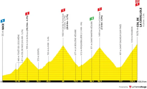
Stage 20: Nice - Col de la Couillole, 133 kilometers
Stage 20 will be the final day in the mountains for the Grand Boucle, short in distance however it'll be in the Alpes Maritimes that it'll take place, a rough day with four categorized climbs including the Col de Braus, Col de Turini, Col de la Colmiane and the Col de la Couillole - all frequent appearances as the queen stages at Paris-Nice.
All constant climbs with short distances. Ordinarily not a day to make massive differences, but it's stage 20 of the Tour and the day after a beastly mountain stage so more can happen here than what is usually the case. The riders start off in Nice and after a few kilometers, tackle their first big challenge: the Col de Braus. 10.2 kilometers at 6.3%, it ends with 109 kilometers to go. The breakaway of the day should be formed here.
Next up the hardest climb of the day in my opinion, the longest of the day as well which is the Col de Turini. 20.8 kilometers at 5.7%, it's final 12 kilometers average 7% and the summit is at 1600 meters of altitude. The climb ends with 73.5 kilometers to go but no big moves are expected here however.
Next up the Col de la Colmaine which is 7.5 kilometers at 6.9%. Nothing too special about it, but it will add to the difficulty of the day and not provide the riders with restbite ahead of the final ascent. This one ends with 37.5 kilometers to go.
Finally, the Col de la Couillole. The last true mountain of this year's Tour and also the final summit finish of the race. The climb is 15.8 kilometers at 7.3% which is quite hard. It's very constant however, but the gradients will be enough for serious attacks to be dealt.
Read also
Stage 21 (ITT): Monaco - Nice
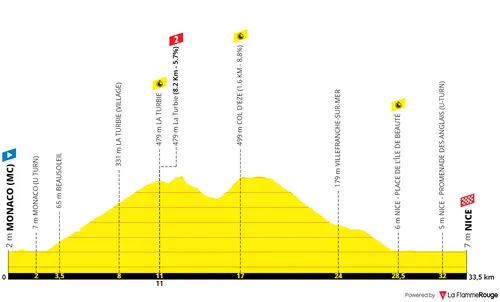
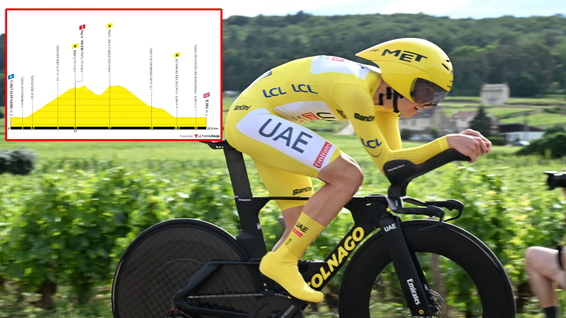
Stage 21 (ITT): Monaco - Nice, 34 kilometers
The final stage of the race. This 35-kilometer route will include the ascents to La Turbie (8.1Km; 6.5%) and a short hilltop to the Col d'Èze (1.6Km; 8.1%) before descending down to Nice where the race will finish this year. A different finale, from Monaco to Nice we are set for a big spectacle.
The start in Monaco will be very stylish but there will only be a few minutes of 'enjoyment' before climbing La Turbie. The ascent will be 8.2 kilometers long at 5.7% and there will be an intermediate point at the top which will provide insight to climbing legs.
After a little bit of rolling roads there is the small Col d'Èze which is 1.6 kilometers at 8.88, those looking to fight for time will go all-out to the limit here as a long descent follows. In time-trial bikes this descent can be dangerous however, it is technical and also quite steep at points. Only the final 5 kilometers then are flat, going back and fourth in the beachside of Nice before reaching the finale of the Tour.
Read also
claps 1006visitors 7
Just in
Popular news
Latest comments
- Not only will the great narcissist get his voice, but he'll benefit financially from this as well. Who says that cheating and lying your way to victory doesn't pay?
 santiagobenites17-02-2026
 - It'll make a good double feature with the Michael Jackson soft focus biopic.LumbarDeniro17-02-2026
- Yeah, whilst MVDP would never break a bone on the MTB... 😂Sexass17-02-2026
- I think he looses too much weight and that leads to his implosions, when he doesn't worry about it or can get it exactly were he wants, like 2024 tour, he is betterjad2917-02-2026
- King of ROAD cycling, because "Mathieu has no equal on the bike" Put Pogačar on a CX bike or a mountain bike and he'll break a few bones.
 Rafionain-Glas17-02-2026
 - Great! A grandiose narcissist finally getting his voice. /sPedalmasher17-02-2026
- It's interesting now because it's in both of their interests to attack - Del Toro because he needs to put big time into Remco, while Remco, despite being the leader, is not as fast as the Mexican and probably wouldn't want to take it to a sprint
 Rafionain-Glas17-02-2026
 - where is the outcry about Remco losing weight for the tour, like there was for PFPmij17-02-2026
- After Moscon, cycling needed a new villain. in Jan we trust. Ayuso was merely a villain to his teammates.abstractengineer17-02-2026
- Bad not as bad as Van Gills. Diamond cut diamond.BenAflec17-02-2026
Loading
Write a comment

